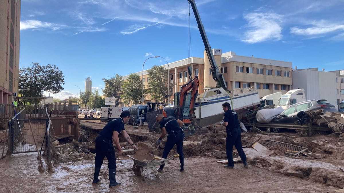
Most days, it’s hard to imagine Valencia as a city threatened by catastrophic floods. The sun shines more than 300 days a year, and the rivers that supply the city and surrounding huerta — the Júcar and the Turia — trickle by with low water volumes in Valencia’s semi-arid climate.
But throughout its history, Valencia has repeatedly suffered devastating floods triggered by sudden, violent rains. For anyone who calls this city home, it’s worth knowing when these events are most likely to happen — and what to do if one strikes.
What Is a DANA, and Why Does It Matter for Valencia?
Every autumn and spring, Valencia faces the risk of sudden, heavy rain and flooding from a seasonal weather phenomenon known as a DANA, or gota fría.
A gota fría — literally “cold drop” — is the popular name for what meteorologists call a DANA (Depresión Aislada en Niveles Altos, or Isolated Depression at High Altitude). It occurs when a cold polar air mass from the jet stream collides with warm, humid air over the Mediterranean. The clash often produces intense downpours, flash floods, and even hailstorms, particularly in late summer and early autumn.
These storms have left a deep mark on Valencia’s history — the Barranco del Poyo alone has flooded around 100 times in the last 250 years. The devastating 1957 Turia River flood, also caused by a DANA, killed dozens inside the city and ultimately led to the river being rerouted into the cement channel that now rings Valencia. The old riverbed became the city’s beloved Turia Gardens.
The deadliest disaster in recent memory struck on 29 October 2024, when record rainfall triggered catastrophic flooding that killed 229 people — most of them in L’Horta Sud — according to the official count confirmed by Spain’s judiciary in 2025. In response, Valencia has strengthened emergency protocols and is planning new green-space parks to help absorb excess rainwater during future storms.
Which Areas of Valencia Are Most at Risk?
To understand why Valencia is vulnerable, pull out a map. The city is ringed by green mountains and hills, while Valencia itself sits on a coastal alluvial plain atop a web of waterways running toward the Mediterranean.
That network of water and runoff from the mountains to the sea is exactly why Roman legionaries founded the city of Valentia in 138 BC, staking a claim on an island in the Turia to take advantage of the soil’s extraordinary fertility and natural irrigation.
But the huerta — the fertile, peri-urban agricultural land ringing the city — is now strained by metropolitan expansion and urbanizaciones that have too often ignored the natural geography, to the region’s detriment.
The 2024 DANA ravaged the areas of L’Horta Sud surrounding the Barranco del Poyo — a University of Valencia study later found peak flows there equivalent to two Olympic pools per second, with narrow channel points downstream driving the worst overflows. But it’s not the only area at risk. Spain’s official flood zone map, SNCZI, flags several others: the Carraixet waterway just north of the city, flowing past Bétera, Moncada, and Tavernes Blanques, which has narrowly avoided major flooding in recent DANAs; and the inland arroyos and canals branching off the Turia near La Cañada, Paterna, and Manises.
How to Prepare for a DANA Emergency
Know your risk. Check your neighborhood’s flood risk on the SNCZI map and know where to reach higher ground. The EU recommends every household keep an emergency kit with food and water for 72 hours, a first aid kit, and a portable radio.
Mind your building. Underground basements are among the most dangerous places to be in a flood — nearly half of the victims of the 2024 DANA were residents trapped in basements after trying to move their vehicles. Open terraces are an overlooked risk too; keep their drains clear so water has somewhere to go instead of into your home.
Follow the forecasts. Despite Valencia’s seemingly endless sunshine, check weather updates from AEMET Valencia regularly. A storm elsewhere in the region can trigger flash floods far from where it’s raining. In October 2024, more than 700 liters of rain per square meter fell on Turís in 24 hours — enough to submerge a car and sweep it away — while residents closer to the coast saw barely a drop and had no idea a wall of water was headed their way.
Understand the alert levels. Emergency 112 Comunitat Valenciana and the Ayuntamiento issue three levels of warning. Yellow means low risk, requiring awareness and precaution. Orange means moderate risk, with some preventive measures such as park closures and reduced travel — a good moment to check your home and go over your emergency plan. Red is the highest risk level: avoid travel and stay away from waterways and the coast entirely.
In severe cases, the Valencian government also sends an ES-Alert to every mobile phone in the affected area, sounding an alarm with an urgent warning. Don’t ignore it — follow the guidance and stay aware of what’s happening around you.
Finally, in an emergency, call 112. Operators are trained to respond in English as well as Spanish.
It’s often hard for new arrivals to imagine this sunny city in a state of emergency. But if Valencia is your home, it’s worth being prepared. And if you rely on buses, trains, or the metro, keep an eye on Metrovalencia and EMT Valencia for service updates during severe weather.